


Geo Metadata and Spatial Relationships- Adding Geodata to Photos.
Anthropologists and social scientists will often conduct ethnographic research at more than one field site over the course of several years. If photography and videography are an important aspect of your field research methodologies, you will soon acquire a large collection of digital data. Keeping this data catalogued properly is the only way to guarantee that you will be able to find images or footage when needed. Ensuring that you add geographic metadata or geotags (also referred to as “geo metadata” or “geodata”) to photos will add a powerful analytical tool to your organizational framework.
In a previous article, I have discussed how DAM (Digital Asset Management) software tools are indispensable initially for cataloguing and searching digital collections and then later for comparison and analysis. DAM software enables users to categorize physical, cultural and behavioral phenomena according to descriptive and analytic criteria.
My PhD cultural anthropology research involved a multi-year ethnographic study of civil society and religious sectarian groups in north China. The methodology I employed as well as theoretical and analytical methods were strongly influence by my Master’s and an undergraduate training in geography that emphasized the importance of spatial relationships, maps, and the interconnection of cultural phenomena with space and distance. An important aspect of my photography has been to document cultural and physical landscapes of my study region. Having geodata attached to photographs is important not only for documenting where the photo was taken, but also for the spatial comparison and analysis of cultural phenomena.
Some digital cameras and nearly all smartphone cameras have GPS chips built-in that embed the latitude and longitude metadata (also referred to as ‘geodata’) into the photos themselves. When these photos are imported into a software application such as a DAM that can read geodata, you will be able to see on a map exactly where on the earth’s surface your photo was taken.
But what about collections of photos that do not have any geographic metadata? If we want to add geodata to a photo, several solutions exist.
Because some of these have been written about elsewhere, I will provide only a brief explanation before focusing on the solution that I’ve found most effective.
Adding GPS metadata to an existing collection
If you want to add GPS metadata to photos that already exist in your collection, this can be done using a number of open-source, free, or proprietary software tools.
1. Low tech, but troublesome solution
Software that allows you to manually edit the EXIF data in photos such as the brilliant open-source EXIF ExifTool GUI for Windows will require you to directly enter the latitude and longitude at which the photo was taken.
You can find the latitude and longitude locations for most places in the world using:
- LatLong.net http://www.latlong.net/
- WorldAtlas: http://www.worldatlas.com/aatlas/latitude_and_longitude_finder.htm
- CalculatorCat: http://www.calculatorcat.com/latitude_longitude.phtml
This site also includes a tool that converts decimal latitude/longitude to degrees, minutes, and seconds. - GoogleEarth: http://www.googleearth.com Install GoogleEarth software. After finding the location of your photo, click on the yellow push-pin in the menu. Reposition the push-pin on the map until it is in the desired location. The Lat-Long coordinates will appear in the properties box.This solution is troublesome and impractical for adding geodata to hundreds of photos.
2. Better solution.
Use a software application that allows you to select the photo location on a map and directly embed the geodata Lat-Long coordinates into the photo or into a sidecar file that contains the photo’s metadata. Both free and propriety software with this ability is available including:
GeoSetter (freeware)
http://www.geosetter.de/en/
Freeware tool for Windows. Easy to use and highly regarded.
Development on Geosetter ended in 2011. It won’t be able to add metadata to new RAW formats that appeared after 2011.
GPicSync (open source)
https://code.google.com/p/gpicsync/
Open Source tool for Windows that enables geotagging of photos. It embeds geocodes directly into the photo’s EXIF metadata. The software is built around the famous EXIFTool and will be able to add geodata directly to RAW images (formats include arw, cr2, crw, nef, pef, raw, rw2, orf, dng, raf, mrw).
NOTE: photo from https://code.google.com/p/gpicsync/wiki/ScreenShots” width=”1893″ height=”750″ /> NOTE: photo from https://code.google.com/p/gpicsync/wiki/ScreenShots
DigiKam (open source)
https://www.digikam.org/
Open Source photo management tool that enables geotagging of photos.
Corel Paintshop Pro x6 and x7 (proprietary)
http://www.paintshoppro.com/en/products/paintshop-pro/ultimate/default.html?hptrack=mmpsp
Paintshop Pro X7 is a well-regarded advanced photo editor that includes the ability to add geodata to photos. While not as powerful as Adobe Photoshop, it is a very capable editor. It is frequently on sale for less than $50 CAN.
Adobe Lightroom (proprietary) $170 CAN
http://www.adobe.com/ca/products/photoshop-lightroom.html
Lightroom 5 is a very convenient RAW editor and simple DAM application for cataloguing and sorting photos. Adding geodata to photos is simple using its map panel. Adobe may switch Lightroom to a monthly rental license (“Creative Cloud”) which will lock you into paying for their service forever if you want to maintain access to your own data. For this reason, I recommend avoiding Adobe product.
Imatch 5 (proprietary) $110 USD
http://www.photools.com/
Imatch 5 has provided the best solution for my workflow. It is brilliantly designed, updated frequently, and well supported. See my review of this powerful Digital Asset Management (DAM) application here.
An extensive list of software that can add geodata to photos can be found here: https://code.google.com/p/gpicsync/wiki/OtherGeocodingSoftware
Thanks to the brilliant designer of gpicsync for compiling this list and for creating gpicsync and releasing it under an open source license!
Adding GPS metadata to photos as you take them.
If your camera has a built-in GPS, then you can ignore this entire post. But if it does not, then several solutions exist.
1. Use a dedicated GPS device or smartphone app to track your route as you take photographs. Later you can use software to automatically correlate the GPS track data to the timestamp on photographs. For several years, I geotagged photos using a Garmin Etrex Vista Hcx to log my location. After uploading my photos, I used software to sync the photos with the geotrack created by the Garmin. The process is relatively straightforward and can be done using proprietary software like Imatch and Lightroom, or by open source software like digiKam. Numerous guides can be found online including this detailed explanation http://www.instructables.com/id/GeoTagging-with-a-Standalone-GPS-Unit-GeoSetter/?ALLSTEPS
2. Connect a bluetooth adapter to your camera that can pair with a bluetooth enabled GPS device. Commonly mentioned solutions include connecting Solmeta or Aokatec AK-4NII bluetooth devices to a cameras, and using a Holux M-1000C Bluetooth Data Logger to provide the GPS location. Though many users claim this is a reliable solution, I find it inelegant and troublesome and reliant on questionable products. You will need to purchase both a bluetooth device to attach to your camera and GPS logging device and take care to ensure the bluetooth wireless signal remains synced. The GPS logger batteries must be charged every day. This is not a solution that I would recommend.
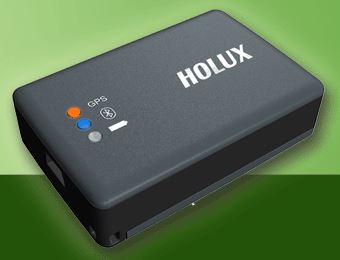
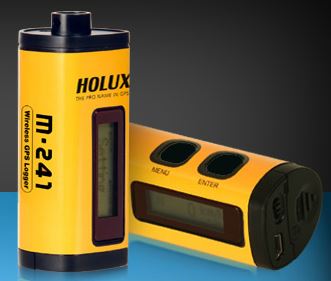
NOTE: photos from http://www.holux.com
When doing fieldwork in remote locations, I always try to follow the principles of “Less, Smaller, Lighter, Simpler” with relation to the gear I must carry and manage. Solutions #1 and #2 break nearly every one of these principles and present many opportunities for things to go wrong such as:
- forgetting to turn on the GPS device,
- the GPS device runs out of power,
- a poor quality GPS unit failing to connect to a satellite
- loss of bluetooth signal
- two pieces of equipment increases the chance of breakdowns
- more complex workflow requiring you to sync the GPS track with the photos
- Less accurate GPS data because the GPS logger only updates the track at a predetermined interval
3. Connect a GPS device directly to your camera and embed geodata directly into photos. An internet search will reveal a number of products with this ability. Nikon, Canon and other third-party companies make GPS adaptors that mount either on the camera hotshoe and are attached to the camera by cable, or that attach to the camera via a cable. The cables invariably get in the way, can easily detach, and must be disconnected in place in your camera bag. This was unsuitable for my work which requires me to have my camera at the ready at all times ready to shoot. I needed a tiny unit that could remain attached to my Nikon for instant use.
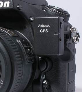
Further searching revealed tiny GPS units that attach to various brands of SLR cameras. The Aokatec GPS devices attach directly to Nikon cameras. These devices costing around $50 are made by an electronics firm China and are of questionable quality judging from user reviews. I would strongly recommend against using unknown make-shift products as the likelihood that will break while you are in the field is quite high.
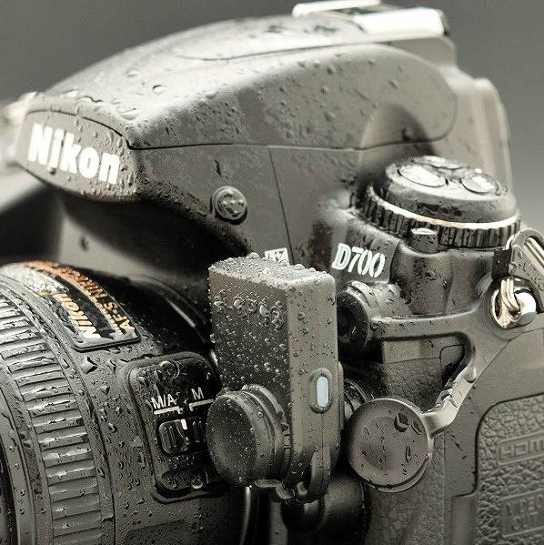
Luckily, I came across the tiny GPS units for Nikon and Canon SLR cameras manufactured by Dawn Technology. The company makes a range of products for Nikon and Canon prosumer and professional cameras. I have been using the di-GPS unit since late 2013 and have been very impressed with its outstanding reliability and performance. For further reading, see my detailed review of the Dawn Technology di-Eco ProF for Nikon here.

You must be logged in to post a comment.