Skip to navigation
rayambros@gmail.com      +421 900 123 456     

Welcome to Ambrosi.ca

Get In Touch Email: rayambrosi@gmail.com Phone: first contact me by email

Donate to support this site

Donations fund this site and ongoing ethnographic research on folk martial arts and traditions in rural north China. This includes the purchase of hardware, equipment for data analysis and field expeditions.

Donate Button with Credit Cards

Open extra topbar
Ambrosi.ca logoAmbrosi.ca Ambrosi.ca Trimal Documents & Consulting
  • Search
Skip to content
  • Trimal Documents 三合文件与咨询
    • I. Editing and Proofreading, Writing and Educational Consulting 编辑,文书写作和教育服务
      • Three Levels of Service 编辑/改写服务项目
      • Calculating Costs 计算费用
      • How we begin 怎样开始
      • II. Interpreting, Seminars &Teaching TOEFL, SAT, GRE 培训,翻译服务和研讨会课程
    • Meet The Trimal Team 认识我们Trimal团队
      • Harry Hu
      • Raymond Ambrosi
    • ESL Study Material 辅助学习
      • Links to Materials 资料链接
      • Trimal Blog 博客
    • Download Trimal Info sheet 下载Trimal的介绍
  • Photography Gallery 照片图库
    • Kazakhstan 哈萨克
      • Horseback Riding on the Kazakh Steppe
    • China photos

      • Wanshou Temple, Beijing
    • Saskatchewan 薩克斯其萬省图库
      • Nicholle Flats at Buffalo Pound
    • Nepal 尼泊尔图库
  • Meihuaquan Research 梅花拳研究
    • GroundUP and Sustainable Communities in North China
    • Euraxess Science Slam 2014. Meihuaquan & Community Life 梅花拳与社群的建设
    • Meihuaquan & martial arts 梅花拳和武术
    • Yongnian Meihuaquan Teaching Centre. 永年县梅花拳传播基地网站
    • Rural Meihuaquan Traditions- Old martial art brings new spirit to rural China 乡村传统- 古老武术令中国农村焕发生机
  • Gear & Equipment Review 设备评估
    • Software
      • MaxQDA Qualitative Data Analysis (Coming Soon)
      • PhraseExpress Text Expander (NEW)
      • Quoppa Software’s PDF Studio
      • TheSage English Dictionary and Thesaurus
      • IMatch 5, DAM software and Social Science Research
      • Adding Geodata to Photos.
      • Information Managers for Research
      • MyInfo Freeform Personal Organizer. (Under revision!)
    • Photographic equipment
      • Guide to Slide and Negative Scanners (Coming Soon)
      • Review of Dawn Technology di-GPS Eco ProF unit
    • Other Gear
      • Kurokesu C2 camera compared to four other webcams
      • Lenovo Thinkpad W520- A fire hazard? (NEW)
      • Powerfilm AA Solar Charger (Coming Soon)
      • Wonpro Europlug Power Strips and Surge Protectors (in-depth review awaiting technical data from Wanpro)
  • Ambrosi Printers
    • Articles by Phil
      • Founding of Ambrosi Printers
      • Ludlow Recollections (NEW)
      • Wrapping a Parcel (NEW)
      • Printing ButterWrap- memories from the 50s (NEW)
      • Grainfetti (NEW)
      • Type casting and type setting
    • Letterpress equipment and books
      • Type Cases Ambrosi Collection (NEW)
      • Steel Die Engravings (NEW)
      • Last Font of Wood Type
      • Papier-mâché newspaper mats from 1937
      • Type Cases
      • Ludlow sticks and letterpress printing
      • Zinc and Magnesium Cuts
      • Assorted Items
      • Typography Books on Letterpress Printing
    • Ambrosi Printers in Media
      • Phil Ambrosi will soon be packing it in
      • Rest in Print
      • Briar Press: Ambrosi Printers Letterpress
      • “An Old-Time Type of Printer.” Regina Sun. 2000, April 23, Sunday
    • Virtual Tour (Coming Soon)
  • Important Stuff
    • COMN 154 Wordle Vocabulary Word Cloud
    • SPCH 154 Wordle Vocabulary Word Cloud
    • NATHM College Student’s Earthquake Relief Aid (NCSERA)
    • About 关于
      • Blog 博客
      • Contact
      • Curriculum Vitae
Menu
Close search form
Equipment and Gear Review, Photographic equipment

Dawn Technology di-GPS Eco ProF unit for Nikon SLR cameras

January 17, 2015Ramb

Dawn Technology di-GPS Eco ProF unit for Nikon SLR cameras

In a previous article, I discussed the utility of having latitude and longitude locational metadata (also referred to as ‘geodata’) embedded in photographs.

For me, understanding the spatial relationships in my textual and photographic data was an important part of both my Master’s degree research on cultural tourism and economic development. It was also critical in my PhD research on the resurgence of civil society religious organizations in north China. Being able to ascertain exactly where a photo or video was taken is useful for analyzing the interconnection of cultural phenomena with space and distance. Additionally, being able to see the location of a photograph on a regional map can help jog our memories to recall events and experiences. This process of reflection and analysis is crucial for ethnographic work and photographs with geodata can significantly contribute to this process.

If your camera has a built-in GPS, then you do not need to read this post about adding geotags to photos. However, most professional grade cameras as of 2014, for whatever reason, still do not have built-in GPS modules. In 2012 I purchased the acclaimed Nikon D800 for my research work. In order to add geodata to my photos I relied on a Garmin Etrex Vista Hcx to log my location as I took photos and later synced the geotrack from the Garmin with the timestamp on photos using software.

Ambrosi’s Fieldwork Principle: “Less, Smaller, Lighter, Simpler”

This solution (discussed in another article) works well, but did not conform particularly well to my fieldwork mantra of “Less, Smaller, Lighter, Simpler”. Having two pieces of separate equipment made for a more complex workflow– I had to ensure the GPS unit was on, had sufficient battery power, and was time-synced with the camera. After years of experience undertaking fieldwork by myself, I soon learned to minimize all opportunity for equipment failure. The best solution to ensure reliable GPS geotagging of photos was to have a cable-free GPS unit attached to the camera at all times.

My search for such a GPS unit for my Nikon D800 led first to several inexpensive, but rather questionable devices manufactured by small companies in mainland China. I have briefly discussed these options in a previous post.

Further searching led me to the di-GPS devices manufactured by Dawn Technology based in Hong Kong. The company has been manufacturing GPS devices since at least 2005.

di-GPS Eco ProF.  Geotag photos and add geo metadata, adding geotags to photos
di-GPS Eco ProF

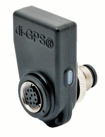
Priced only slightly higher than the questionable no-name devices, the Dawn series of di-GPS modules appeared to be more compact and of professional quality. Although online reviews were hard to find, it appeared that photographers who bought the di-GPS units were very satisfied. After ordering a di-Eco ProF unit for my Nikon D800, I was impressed by the unit’s compact size, weatherproof design and performance. The unit is made of high quality plastic which feels robust and inspires confidence that it can endure difficult fieldwork conditions. It can be attached via the 10 pin port on the Nikon D4, D4S, D3, D3S, D3X, D810, D800, D800E, D700, D300, D300S, D2XS, D2X, D2HS, D200 & Fujifilm S5 Pro. Another unit, the di-GPS Pro L, supports Canon cameras including Canon EOS 40D, EOS 50D, EOS7D, EOS5D Mark II, EOS-1D Mark III, EOS-1Ds Mark III & EOS-1D MArk IV.

Dawn Technology di-GPS Eco ProF. Geotag, add geo meta data, adding geotags to photos
di-GPS Eco ProF in rain

Why did I chose this unit? It is small, weatherproof, requires no batteries, draws very little power, and can remain attached to my camera at all times– even in my camera bag. The di-Eco ProF includes a pass-through port for a 10 pin remote shutter release. With this feature, a shutter release can be used for long exposes or HDR photographs at the same time as the di-Eco ProF geotags photos. When this port is not used, it is covered with a rubber cap.

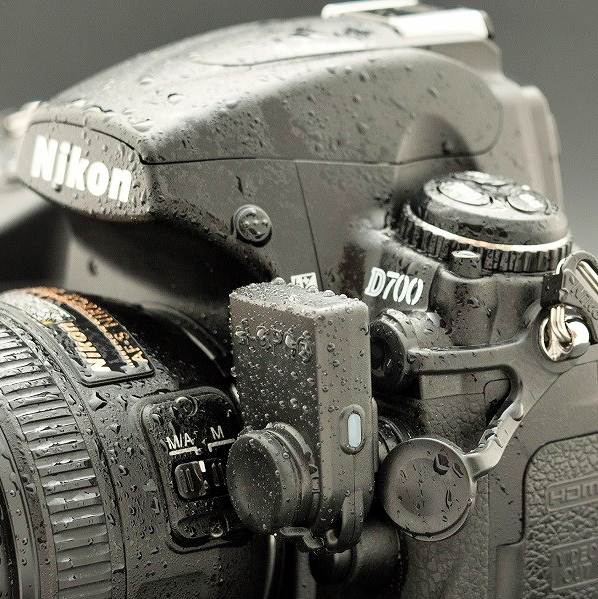
Mounting the unit on my Nikon D800 is somewhat finicky and sometimes requires several attempts before I can get the locking thread to engage with the threads on the D800’s 10 pin port. Once mounted, the di-Eco ProF is quite firmly attached. It has not interfered with switching lenses, but does slightly block the flash compensation button.

The performance of the di-Eco ProF matches its excellent build quality. For the most part, on a cold start (the time needed to lock onto satellites immediately after installing the unit on the camera), the unit can acquire a satellite GPS signal within 40 seconds, closely matching the company’s specification claim. However, under certain circumstances (remote locations, forest cover), it has taken significantly longer but always manages to find a signal. Once the di-Eco ProF has acquired a location, the next time the camera is powered on, the unit can reacquire a signal within 2-5 seconds. Impressive.

If you take photos indoors or in some other location where the di-Eco ProF cannot lock onto a satellite signal, the di-Eco ProF will add geodata to photos based on the last known position. This is a very useful feature for social science research. During my field investigations in rural China, I was in and out of buildings dozens of times each day taking photos inside homes, in the open courtyard of homes, inside temples in agricultural fields. When the event that I was photographing moved from the outdoor courtyard to the interior of a house, the di-Eco ProF assigned the last available GPS position to the photos taken indoors. This is simply the best solution given the limitations of GPS technology– GPS devices require clear access to the sky. Using the last known GPS position is only problematic under certain conditions such as when I took photos at the Summer Palace in Beijing and then took the subway to a new location many kilometres away. Photos taken underground were stamped with the geolocation of the Summer Palace– obviously incorrect. Emerging from the subway, the di-Eco ProF invariably determined my new location in less than a minute.

After shooting tens of thousands of photo with the di-Eco ProF, the unit has performed without fail during fieldwork under less than optimum conditions. With its outstanding weatherproofed construction, it has worked in rain in Vancouver, endured thick duststorms in rural Hebei villages, and functioned perfectly during the -30 degree Celsius Canadian winters. In a perfect world, the di-Eco ProF would be smaller yet, but currently it is by far the smallest and best GPS unit available for adding geographical metadata to photos.

Note: I have also posted a version of this review at the Nikonites forum where the review was read many hundreds of times.
I am surprised to read that some Nikon DSLR users are using clumsy devices like the Nikon GPS unit, or the Micnova device, both of which are inferior to DawnTech’s offering. Several years ago, DawnTech released a new Eco Professional 2 for Nikon DSLRs. I hope to post a review on my site in 2024!

Tags: data organization, Dawn Technology, di-Eco ProF, di-GPS, geodata, geotagging, GPS, metadata, methodology, social science research

About Us

Ambrosi.ca is the homepage of R.P. Ambrosi, qualitative data analyst, consultant, researcher, educator, and writer. This site is composed of five main section: Trimal Documents, Photography, Meihuaquan Research, Equipment and Gear Review, and Ambrosi Printers.

Donate to support this site

Donations fund this site and ongoing ethnographic research on folk martial arts and traditions in rural north China. This includes the purchase of hardware, equipment for data analysis and field expeditions.

Donate Button with Credit Cards

Advertisement

Register and Login

  • Register
  • Log in
  • Entries feed
  • Comments feed
  • WordPress.org

Tag Cloud

Beijing best webcam for online classes civil society community rejuvenation data organization Dawn Technology daytrip di-Eco ProF di-GPS dictionary Earthquake Relief ELP webcam equipment film and negatives film scanner folk religion gear review geodata geotagging GPS industrial webcam Kurokesu Kurokesu C2 webcam letterpress printing Ludlow MaxQDA meihuaquan meihuazhuang metadata methodology Minghe village Mokose webcam parcel photographic equipment photography PowerFilm Solar Panels QDA qualitative data analysis review social science social science research software review text expander webcam review Yongnian County

Categories

  • About (1)
  • Blog (1)
  • China 中国图库 (3)
  • Equipment and Gear Review (12)
    • Other Gear (2)
    • Photographic equipment (2)
    • Software (6)
  • Featured (4)
  • Meihuaquan Research (8)
  • Trimal Editing (1)
    • Trimal Blog 博客 (1)
  • Uncategorized (1)
  • Uncategorized (11)

Archives

  • March 2023 (1)
  • November 2015 (1)
  • July 2015 (1)
  • June 2015 (2)
  • May 2015 (4)
  • February 2015 (4)
  • January 2015 (9)
  • December 2014 (4)
  • October 2014 (6)
  • April 2014 (3)
  • March 2014 (1)
  • February 2014 (4)
  • December 2013 (1)

Projects

Sorry, there is nothing to display here…

News

Kurokesu C2 industrial camera

Kurokesu C2 camera compared to four other webcams

March 20
Lenovo battery recall 2015 fire hazard

Lenovo Thinkpad W520- Great Laptop, Yet a Fire Hazard?

November 1
Lulow with matrix cabinet

Ludlow Recollections

July 9
GroundUp http://www.groundup.archi/

GroundUP and Sustainable Communities in North China

June 11

Wrapping a Parcel

June 2
Geo Metadata and Spatial Relationships- Adding Geodata to Photos.Guide to Slide and Negative Scanners

Get In
Touch

Address:

Ambrosi and Trimal Documents
Regina, SK, Canada

Email address:

trimalediting@gmail.com
rayambrosi@gmail.com
or use contact page

Recent
News

Kurokesu C2 industrial camera

Kurokesu C2 camera compared to four other webcams

March 20
Lenovo battery recall 2015 fire hazard

Lenovo Thinkpad W520- Great Laptop, Yet a Fire Hazard?

November 1
Lulow with matrix cabinet

Ludlow Recollections

July 9
GroundUp http://www.groundup.archi/

GroundUP and Sustainable Communities in North China

June 11

Wrapping a Parcel

June 2

Powerfilm AA Solar Charger (Coming Soon)

May 20

Our
Work

Sorry, there is nothing to display here…

Something
About Us

Ambrosi.ca is the homepage of R.P. Ambrosi, qualitative data analyst, consultant, researcher, educator, and writer. This site is composed of five main section: Trimal Documents, Photography, Meihuaquan Research, Equipment and Gear Review, and Ambrosi Printers.

Tags

Beijing best webcam for online classes civil society community rejuvenation data organization Dawn Technology daytrip di-Eco ProF di-GPS dictionary Earthquake Relief ELP webcam equipment film and negatives film scanner folk religion gear review geodata geotagging GPS industrial webcam Kurokesu Kurokesu C2 webcam letterpress printing Ludlow MaxQDA meihuaquan meihuazhuang metadata methodology Minghe village Mokose webcam parcel photographic equipment photography PowerFilm Solar Panels QDA qualitative data analysis review social science social science research software review text expander webcam review Yongnian County

Login

  • Register
  • Log in
  • Entries feed
  • Comments feed
  • WordPress.org

Donate to support this site

Donations fund this site and ongoing ethnographic research on folk martial arts and traditions in rural north China. This includes the purchase of hardware, equipment for data analysis and field expeditions.

Donate Button with Credit Cards

© Ambrosi.ca
Cleantalk Pixel
 

Loading Comments...
 

You must be logged in to post a comment.